Squamish to Indian Arm – Mamquam and Stawamus/Indian River FSR’s
- biegandrew
- Sep 4, 2023
- 3 min read
Updated: Sep 14, 2023
Summary of Route
- Type: Out and back; oceanfront camping
- Rating: 4/5
- Season: Summer
- Length: 38 km’s one way from start of gravel road
- Vehicle suitability: Stock 4x4

The Route
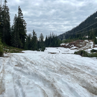
The Squamish to Indian Arm overland route has the potential to be a classic route for any Vancouverite as it brings you to the north end of Indian Arm, directly across from the Wigwam Inn. This is a relatively easy route; however, several portions contain loose gravel and are somewhat rocky. Airing down is not necessary but will increase comfort. Despite its relatively low elevation, this route is impassable until the heart of summer due to the surprising prevalence of snow at the 13 km mark. At the end of May 2023, over 6 inches of snow remained at this point despite a very warm spring.
Access for this route occurs just south of Squamish on Mamquam FSR (GPS coordinates: 49.68866, -123.14581), approximately 200m south of the Squamish Valley Gas Bar. Once on Mamquam FSR travel east for approximately 3.8 km’s until you reach the below intersection (GPS coordinates 49.70619, -123.10511). Bear right onto Stawamus/Indian River FSR. You will stay on this road for the entirety of the drive.


Almost immediately the route begins to climb and the first test of your vehicle’s suitability for this drive occurs. If you struggle with this hill climb we do not recommend continuing as harder sections lie ahead. Shortly after this steep portion you will encounter one of the few intersections on this route. Stay left to continue to Indian Arm.


After approximately 8 km’s of travel you will reach an adequate pull out to spend the night should you be arriving on this route late in the evening. Views of the surrounding mountains begin to open up at this point. An additional 4.7 km’s of travel will bring you to a beautiful little lake just off the side of the Stawamus/Indian River FSR (GPS coordinates 49.64396, -123.03808). This lake is shallow but presents a wonderful spot for dogs to cool down. Remarkably, this is the area where we encountered snow on May 24, 2023.


Continuing on, travel is easy and road conditions are for the most part excellent. A few small creek crossing are required but the road is firm throughout all of these. After having travelled 23 km’s in total, views of the Indian River will begin to open up. Walk-in access to beautiful, calm sections of the Indian River can be found throughout the remaining drive in addition to expansive views of the surrounding peaks.


If you’re seeking vehicle accessible camping, adequate sites can be found after travelling another 7 km’s at GPS coordinates 49.52718, -122.90400 and 49.51071, -122.90152. The first of these sites is a pull-off but well enough recessed from the Stawamus/Indian River FSR to provide comfort. The second of these sites requires a slight detour and presents an open meadow for camping. While the second site provides greater privacy, accessing the Indian River requires a greater walk.
While the foregoing sites are adequate, the crowning jewel for camping on this route is found after you have travelled approximately 37.4 km’s. As you begin to approach the delta where the Indian River meets Indian Arm you will notice a peninsula extending to your right. As you approach, take the below turn to gain access to an isolated campsite with wonderful views south down Indian Arm (GPS coordinates 49.46771, -122.87943). There is room for several vehicles to camp on this peninsula; however, the proximity of sites makes them not ideal for any but a group.


Should this peninsula be occupied, consider proceeding further south along Stawamus/Indian River FSR for an open space, utilized for Search and Rescue staging, which could be utilized in a pinch for camping. Alternatively, consider back tracking for 4.2 km’s to GPS coordinates 49.50279, -122.89203 and exploring the logging roads leading north east towards Norton Lake Recreation Site.


If you’re looking for further exploration after completing this route, consider travelling further north to the town of Pemberton, British Columbia, and completing our South Chilcotin Overland route or our Harrison to Pemberton Overland route in reverse.