
Kafir Peak – D’Arcy/Micro FSR
- biegandrew
- Jul 24, 2023
- 2 min read
Updated: Feb 10, 2024
Summary of Route
- Type: Out and back; mountain top car camping
- Rating: 4/5
- Season: Summer
- Length: 11km one way from start of gravel road
- Vehicle suitability: Stock 4x4

The Route
The Kafir Peak – D'Arcy/Micro FSR overland route is an excellent relatively easy route that allows for access to an elevation of 1900m with big views in all directions and multiple camping opportunities.
Access occurs 39km north-east of Pemberton, British Columbia off of Pemberton-Portage Road. Follow signs for Birkenhead Lake, turning left off of Pemberton-Portage Road at GPS coordinates 50.52061, -122.50343. Follow the well-maintained wide gravel road for 0.9km turning left onto an offshoot for D’Arcy/Micro FSR (GPS coordinates 50.52827, -122.50434). Once on the D’Arcy/Micro FSR bear right at the first intersection and follow the road in best condition for the remainder of the drive. Alternatively, Google maps appears to provide the correct route from a search query of “Kafir Peak”.


As of 2023, the majority of D’Arcy/Micro FSR is in good condition and generally passable in 4-high; however, many portions are quite steep and older vehicles may struggle. Portions of the road are beginning to suffer from erosion and this road may become more difficult in the future.
As you proceed to climb, much of the drive is shaded and little views are to be had. At 6.5km in, an off-shoot logging road requiring a small ditch crossing presents the first opportunity for views and camping (GPS coordinates 50.52898, -122.55584).


Returning to the main FSR, continue your climb. Another 2.5km’s will bring you to the first of the sites found near the top of Kafir Peak. This site presents wonderful views north east with peak-a-boo views of Anderson Lake from a short walk. There is sufficient room at this site for multiple vehicles.

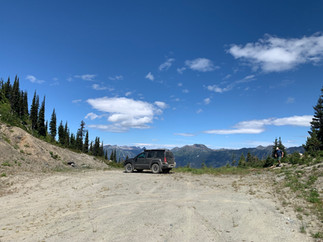


An additional site can be found by proceeding slightly further along D’Arcy/Micro FSR, despite all reviewed maps failing to indicate that this road continues. This section is the most difficult of the entire drive; however, it is brief (approx. 200m) and the views do not disappoint. Once up this final portion, the obvious campsite appears with northwesterly views. Exploring this area on foot will provide ample views in all directions. There is space to turn around and several vehicles could comfortably camp here.


Both of the sites found at the end of D’Arcy/Micro FSR are in proximity to cell-towers. During our time there we did not notice any noise from these towers and there are no “no camping” signs present. There are no water sources present at the top of Kafir Peak.
Looking for other easy, high elevation routes? Consider our Road to Liumchen Lake and Grasshopper Ridge overland routes!


