Chipmunk Caves and Foley Lake – Chilliwack Lake Road and Foley Creek FSR
- biegandrew
- May 6, 2024
- 3 min read
Summary of Route
- Type: Out and back; caves and lakeside camping
- Rating: 3/5
- Season: Spring to Fall
- Length: 32.7 km’s one way
- Vehicle suitability: Stock 4x4

The Route
The Chipmunk Caves and Foley Lake overland route is an easy, low commitment route great for a shorter outing or the early season while snow is still present at higher elevations.
Located south east of Chilliwack, British Columbia, this route begins on Chilliwack Lake Road (GPS coordinates 49.09734, -121.96365). Once on Chilliwack Lake Road, travel for approximately 25km’s to GPS coordinates 49.09975, -121.64040, whereby you will encounter the below pull out and parking lot for Chipmunk Caves. “Chipmunk Caves” can be entered into Google Maps for ease of navigation.


Once parked at the obvious “Cave Parking Anytime” sign, proceed past the yellow gate down the main road option. Bear right at all intersections and this road will eventually narrow into a single-track path.


Before long you will reach the Chilliwack River and some wonderful tent camping sites. After enjoying the views, take the single-track path to your left. After approximately 300 meters you will gain your first view of the caves. The easiest access cave is somewhat underwhelming; however, if you brought a headlamp and appropriate shoes there are plenty of more challenging caves to explore. Aside from the initial cave, these caves are not dog friendly.


After having explored the caves, return to your vehicle and continue proceeding east along Chilliwack Lake Road for approximately 1.1 km’s, turning left onto Bench FSR (note: all consulted maps indicate this is Foley Creek FSR despite the below signage). At Bench/Foley Creek FSR you will see the below sign indicating "Welcome to the Chilliwack River Valley".


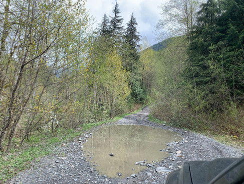
Once on Foley Creek FSR, travel for 2.1 km’s until the next intersection (GPS coordinates 49.11154, -121.63142) and then bear right. Be aware that the next kilometer or so of travel on Foley Creek FSR was being actively logged when we travelled this route in May 2024. Otherwise road conditions are good albeit many large puddles were present at the time of travel and some sections were sufficiently rocky to cause problems for vehicles with limited clearance.


The remainder of the route is relatively straightforward; however, there are several side routes that can be explored should you have the time. If your goal is Foley Lake, continue following the main road (Foley Creek FSR) for approximately 4.7 km’s. The first access for lakeshore camping at Foley Lake occurs at GPS coordinates 49.12522, -121.58283 at the west end of Foley Lake. Entry and exit from this site with a vehicle is challenging despite not appearing so in the below photos.


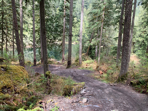
An additional 300 meters of travel will bring you to our preferred site at GPS coordinates 49.12567, -121.57935. Access is easier and the views are better than the prior site. Entry should be manageable in any 4x4; however, we recommend scouting the entry and exits points before to ensure you are comfortable with the terrain as gravity will be working against you upon your departure.


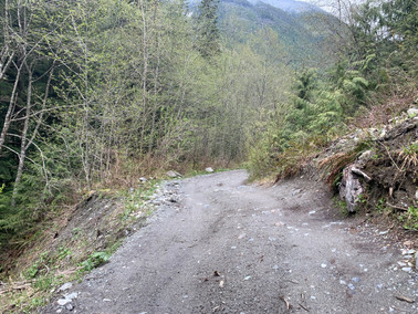
After this point road conditions steadily deteriorate. Several portions of the road become quite narrow with signs of erosion readily apparent and creating substantial risk should you misjudge your vehicle's size. Should you choose to continue, the north end of Foley Lake has several more suitable campsites. Most of these are dispersed around Foley Creek; however, it appears that with a commitment to multiple creek crossings one may be able to gain access to the north east end of Foley Lake. We did not attempt these crossings and cannot accordingly comment on their depth or difficulty.


If you have more time in the area, consider checking out our more challenging Upper Bridal Falls route. For other easy routes not in the immediate vicinity, consider our Gillis Lake to Murray Lake or Kafir Peak routes!